GUIDE TO THE CITY OF GRAN DAR
1563 4D
Introduction
The city of Gran Dar, usually called simply the City, is the largest subterranean urban structure on Tarnus, much larger than Monford or Purusil or any other inhabited space. It is estimated to reach nine kilometers below the surface of the planet, and spreads out about ninety kilometers in diameter, counting all the outliers and connecting communities and facilities bound closely to its workings. The actual convex contour of the City proper is that of an oblate spheroid 70 kilometers across and 9 kilometers deep, with one pole at the planet‘s surface, the other directly below it at the unreachable bottom of the City. The lowest explored level is 7800 meters down from the surface.
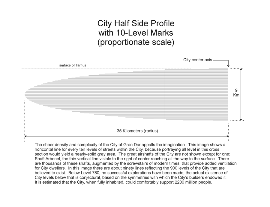
The sheer density and complexity of the City of Gran Dar appalls the imagination. The City Profile shows a horizontal line for every ten levels of streets within the City, because portraying all level in this cross section would yield a nearly-solid gray area. The great airshafts of the City are not shown except for one: Shaft Arbonel, the thin vertical line visible to the right of center reaching all the way to the surface. There are thousands of these shafts, augmented by the screwstairs of modern times, that provide added ventilation for City dwellers. In this image there are about ninety lines reflecting the 900 levels of the City that are believed to exist. Below Level 780, no successful explorations have been made; the actual existence of City levels below that is conjectural, based on the symmetries with which the City‘s builders endowed it. It is estimated that the City, when fully inhabited, could comfortably support 2200 million people.
The City is carved, drilled, and shaped out of a single unusual kind of native rock that seems far too homogeneous, tough, and free of faultlines to be natural in its origin. Analysis of this stone reveals a three-phase material with crystalline, glassy, and metallic structures intermixed so as to produce a workable material of exquisite toughness, hardness, and malleability – qualities which would generally not be shared in a single material, let alone in any form of mineral. The City can be dated by radiological means to an age of at least fifteen thousand years, with almost no deterioration or collapse due to geological processes. This unexpected state of affairs attests to its long-term structural integrity.
The City is essentially a stack of disks of radial and concentric-ring streets around a single central axis. Adjacent layers of the stack are 10 meters apart vertically, yielding a total of 900 levels. Airshafts and stairs give interlayer access. Added interlayer connection is provided by the turnings, a set of broad, sloping streets that spiral out and down from the central axis to define ellipsoidal, concentric, convex contours of the same shape as the City itself.

CITY DATA
The following notes appear in tabular form in the City Structure spreadsheet.
Axial diameter: 9000 meters (top to bottom)
Equatorial diameter: 70000 meters (side to side)
Level vertical spacing: 10 meters
Ringway radial spacing: 100 meters
Radial angular spacing: 45 degrees (at center vertical axis)
Radial multiple: 2
Radial spacing factor: 2
Radial maximum arc separation: 157 meters
Turning angular spacing: 90 degrees
Surface level: 0
Number of levels altogether: 900
Lowest explored level: 780
Turning anchor vertical spacing: 10 levels
CITY UNDERSTREETS
Streets of the City are called ‘understreets'. Travel through the City is mostly on foot. Certain radial and ring streets are reserved for City rail lines, but these are few and mostly in the upper City levels. Walking is the most-favored mode of City travel; vehicles are allowed only for heavy loads, and may only move slowly. Vans carrying all kinds of bulk goods are typical. Lifts appear only sparsely-placed. The need to move long distances physically at high speed only exists on the surface, because virtual presence supplants many needs for going from place to place in the City. For these reasons, stairs are heavily used in local travel.
The cross-section of a typical understreet is standard. There are two common types: major and minor. A major understreet is 10 meters wide, with 3-meter vertical side walls and a circularly-arched ceiling reaching a height of 4 meters at its highest point. A minor understreet is the same height at both wall and center, but has a narrower circular arch in its ceiling, since it is only 5 meters wide. Turnings are larger in both height and width than major streets, and their walls and ceilings are faired smoothly into each other to give a smooth impression rather than a line of transition.
Understreets take one of several different forms:
1. Ringways horizontally circling the axis of the spheroid, in concentric arrangement.
2. Radials emanating outward horizontally from the axis of the spheroid. From the City axis outward, eight radials spread. When the distance between radials, as measured along the arc of an intersecting ringway, exceeds 157 meters, new radials originate at that ringway midway between the adjacent radials from inwards. The new radials are directed outward. The value of 157 meters was apparently chosen because it is the next integer smaller than 100 /2, 100 being the radial distance between ringways.
3. Turnings anchored at the spheroid axis at each end, each one spiraling outward and downward from the top end and crossing intersections of ringways and radials, reaching a maximum radius at the equator of the City spheroid, and then spiraling outward and downward back to meet the center axis once again. The convex contour of each turning is an oblate spheroid of the same shape as the City itself. Turnings are nested like the layers of an onion. Each anchor point for turnings is an anchor point for four turnings spaced evenly in a circle (ninety degrees apart). The turnings are believed to have had ceremonial functions for their builders.
4. Airshafts passing vertically through the City at intervals along the radials and turnings, from the lowest levels to the surface. Access to airshafts is through large, heavy doors leading to nearby understreets through short tunnels. An airshaft may be traversed using the built-in spiral stair along its wall. These airshafts in the City are ancient, existing from the time of the City‘s building, and are often in disrepair and decay. The bottoms of the airshafts are usually filled with debris, sludge, and sewage. The true depth of the shafts is unknown.
5. Access tunnels zigzagging in all three spatial dimensions through the City as needed for provision of water, ventilation, power, communication, sewage, and other services. These tunnels terminate in utility closets with doors providing access from understreets or backburrows.
6. Backburrows serving residences and businesses as rear and side exits for service, emergency, and convenience. Backburrows usually connect with multiple units on either side, and terminate at doors at either end that open onto understreets.
7. Spiral stairs, narrow and heavily-used, are everywhere, opening out onto radials, ringways, and turnings. These are also called screwstairs or screws by City dwellers.
8. Elevators or lifts are prevalent in the upper levels of the City. They are less often operational further down, where vandalism often damages or trashes them, and repairs are infrequent.
Access tunnels and spiral stairs are continually being added to the City. None of the other forms of understreet or tunnel is ever changed substantially, since all the others except the elevators were present when the Colonists first occupied the City, and all agreed not to disturb the ancient subterranean architecture in any significant way.
CITY LEVELS, RINGWAYS, AND RADIALS
Levels are generally spaced 10 meters apart vertically, and are numbered starting with zero at the surface and increasing with depth. From Level 1 to Level 50 the vertical distance is just 490 meters. The surface is considered Level 0. The lowest explored level at the time of Descending Road is 780, at 7800 meters down, in the region called Babiar.
Ringways are spaced 100 meters apart radially. The number of ringways at the City‘s equator is 350. Ringways occur in two types: the minor ringways, which are narrower, at five meters width, and the broader major ringways, each one ten meters wide. Moving outward from the City axis, four minor ringways appear, followed by one major ringway, and this pattern repeats all the way to the City periphery at all levels.
Radials, like ringways, occur in minor and major forms, respectively five and ten meters wide. Originating at the City axis are eight major radials. The radials originating at every second splitting of radials are also major.
CITY TURNINGS
The turnings are a vital part of the City‘s mystery. There are nineteen of these broad, heavily-decorated, gently-sloping streets in the entire City. At each of Levels 0 (the surface crown of the City), 90, 180, 270 and 360, there is a vast circular hall lying exactly at the City‘s central vertical axis. For each of these halls a counterpart hall is situated at level 900, 810, 720, 630, or 540 respectively. At Level 450, the exact center of the entire City, the largest of all the City‘s assembly areas stands, the Great Central Dome, its narrow pillars aligned radially in the eight directions of the radial streets entering. But missing from the Great Central Dome are the four high-arched entrances at the four compass points that lead to the Turnings: the nested spiraling streets that wind around the ellipsoidal shape of the City from each of the upper circular halls listed here to the lower counterpart hall.
Turnings appear to have ceremonial meaning that is lost from before the Arrival of the Colonists, our ancestors. Each turning is deeply inscribed on all surfaces with metal inlay and filigree that appears charged with meaning, but which has resisted all efforts to decode it. Deng Pai-Xin’s comments on the inscriptions are provocative, but amount only to speculation.
From the hall at the axis at Level 0, in the ruins at the surface of Tarnus, the traveler chooses a compass direction and enters the wide, shadowy tunnel leading at first straight away from the axis. See City Turning Paths. At first, both the lateral curvature and the downward slope of the passage are not noticeable – the traveler covers over two kilometers radially before descending one level (ten meters), and the curve to the right amounts to a fraction of one degree. By the time the traveler reaches the tenth level down from the surface, he or she is over seven kilometers in radial distance from the City axis, and by this stage the curve to the right has reached a bearing about four degrees to the right of the entrance direction.
Eventually the traveler reaches the periphery of the City, at Level 450, and then the turning begins to wind its way back toward the center axis, to end (conjecturally, since debris, waste, and sludge has almost completely filled the spaces below Level 780) at the hall at Level 900. The turning originating at Level 90 would end at Level 810. The turning from Level 180 ends at Level 720.
The turnings are concentric, like onion layers. See Turning Shells for a look at three of these layers. The turnings from Level 90 reach a distance of 28 kilometers from the axis before returning, from Level 180 a distance of 21 Km, from Level 270, 14 Km, and from Level 360 a maximum of 7 Km. It has been suggested that a turning may be visualized as the skin of a fruit, done off in a single piece with a spiraling peel.
The attentive reader will note that the full count of turnings should be twenty – four starting at each of five levels — and not nineteen. But for no known reason, the turning leading eastwards out of the axial hall at Level 180 is represented only by a correctly-shaped arch over a smooth stone wall. There is no passage behind the stone. Test drillings at numerous points along what would be the path of the turning yield only native rock, of no particular distinction anywhere. A similar arch and blank wall mirror this state of affairs at what would be the lower end of the turning at the eastern side of the Level 720 axial hall. This baffling puzzle is called The Mystery of the Turnings.
As with the turnings themselves, the mystery offers no clues. Numerous researchers have advanced theories of one sort or another, with each theory usually favoring its researcher’s prejudices and expertise; but none of these conjectures has blossomed into anything verifiable in any way.
CITY CALCULATING TURNINGS
Mathematically speaking, each turning lies just outside the surface of an ellipsoid that may be defined parametrically as follows. If one begins with two free parameters u and v, such that u, v ∈ [0, 2π], each surface point of the ellipsoid may be defined as:
(x, y, z) = (cos(u)cos(v), cos(u)sin(v), 1/2 sin(u)).
To get the City‘s proper size and proportions, one incorporates a radius size factor of 35 to the x, y, and z values, and a ratio of 9/70 for the vertical-to-horizontal proportion of the ellipsoid to the z values.
Each turning may be defined using one free parameter. The path of each turning descends from its top level by one level for each 1/900 of a full circle, or 2π/900 radians. If the parameter is t, such that t ∈ [0, 1], then each point along a turning may be defined as:
(x, y, z) = (r sin(b + 2πt), r cos(b + 2πt), e),
where
b ∈ {0, π/2, π, 3π/2},
s = 1/2
e = s – t,
O = 1/1400, and
r = sqrt(1 – e^2/s^2) + O.
The value of b determines which of the four compass points the initial path of a turning will take. The value of e shifts the interval of the parameter to e ∈ [-1/2, 1/2]. The additive factor O provides an offset outwards for the radial distance to prevent the turnings from intersecting ringways from directly above or below. The value of r derives the radical
sqrt(1 – e^2/s^2)
by treating the City‘s profile as a unit circle and solving for one coordinate in terms of the other. As before, scaling factors are required to get the proper City proportions and sizes.
More detail will be added as the structural model is further studied.
CITY AIRSHAFTS
The great airshafts of the City are a mystery as baffling as the turnings, dating back to the same apparent era. The only obvious uses for them are ventilation to the surface of Tarnus, and sewage disposal, but they seem to have been used for many other things as well, judging from inscriptions, occasional discovered artifacts, carcasses and skeletal remains here and there, doors that work in odd ways, passages leading to unexpected places, and other tantalizing evidence.
The airshafts possess the interesting dynamic characteristic of operating as immense organ pipes when surface winds reach sufficient velocity, but their length, from the surface all the way straight down at least seven kilometers, causes them to set up vibrational modes that can be felt at all levels of the City at once, at considerable lateral distance. Deeply subsonic, these ‘sounds’ can cause considerable emotional disturbance in those within their range.
There are two diameters of shafts. The great shafts, few in number, are 16 meters across at their widest, the more-common basic shafts half that wide. Each airshaft has a spiral stairway one meter wide cut into the native stone around its circumference, in such a way as to make the stairway appear to be growing inward from the shaft‘s cylindrical wall. Each spiral makes one complete turn between adjacent levels, and access to the understreets of each level is via an upward-sloping passageway 2 meters in height. See City Airshaft Section for an example. These passageways vary in length from 4 to over twenty meters, depending on the distance of the shaft from an understreet, and may incorporate 1-4 rooms opening on either side of the passage in no particular pattern. Access to the airshafts is discouraged by the City authorities, so that steel doors with locks are set in place to restrict traffic, but in many City zones the doors are broken off, or the locks are disabled.
Unlike the spiral stairs, the airshafts all have no center stone, and they lack any form of guard rail to help keep their users from falling into the shaft all the way to the bottom. See City Airshaft Plan for some idea of the scale of a typical shaft. The bottom is at about Level 784, 7.8 kilometers down from the surface, where millennia of time, continued usage as a convenient dump, and endless runoff from water and oil sources in the rock have created a seemingly-bottomless sludge of horrific richness, toxicity and stench. The futility of attempting to clean any of this accumulation out to allow deeper exploration is reflected in the City usage “pumping out the lower levels", signifying the impossibility of some task, and at the same time, in the usual ribald City fashion, incorporating an oblique reference to sexual insatiability.
CITY SPIRAL STAIRS
These are the primary means used by most residents to move from level to level within the City. Each one has the shape of a vertical cylinder in the City‘s native stone, with the interior of the cylinder left intact, so that those using the stairs find walls on both sides. These stairs are everywhere. See City Stairway for some detail.
The spiral stairways were begun shortly after the Colonization of the City. Until then, moving from level to level was done only via the airshafts (dangerous) and the turnings (remote and inaccessible). There are two types of spiral stairway: narrow (5 meters in diameter) and broad (10 meters in diameter). Both types spiral their steps around a central stone shaft. The narrow stair steps are 1.25 meters wide, barely enough for two to pass comfortably, whole the broad stair steps are 2.5 meters wide. The step count and pitch vary depending on the age and location of the stairway.
Each spiral stairway has a landing at each level it reaches, and a stage landing halfway between the levels. Each stairway makes two full turns between adjacent levels. Some stairs have doors at each level, and others are open to the levels without access restriction.
Most spiral stairways run for at least ten levels, but a few are sunk more than halfway down into the City from its upper reaches, almost making them rival the great airshafts in their length. In rare instances, spiral stairways may be found which have exits only at certain levels.
CITY DOMES
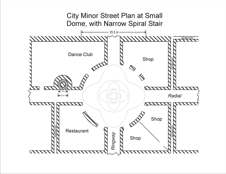
At many intersections of City understreets, domes open out the streets into areas for assembly, commerce, and recreation. The typical small dome, or aswal, is a little over 25 meters across, and offers doorways to spaces which are used variously as shops, offices, eating and drinking places, dance clubs, and occasionally residences. See City Local Street Plan for an example.
These aswals occur at intervals where certain ringways and radials meet, such as in City Streets and Dome. Aswals are larger where turnings cross a level near an intersection. Domes of the 25-meter size also appear on most levels at the City axis, where eight radials lead out from each dome, as in City Streets and Axial Domes.
Where the domes are larger, their arched ceilings must be made higher. In such cases, which occur primarily at the City axis, multiple street levels have access to the dome.
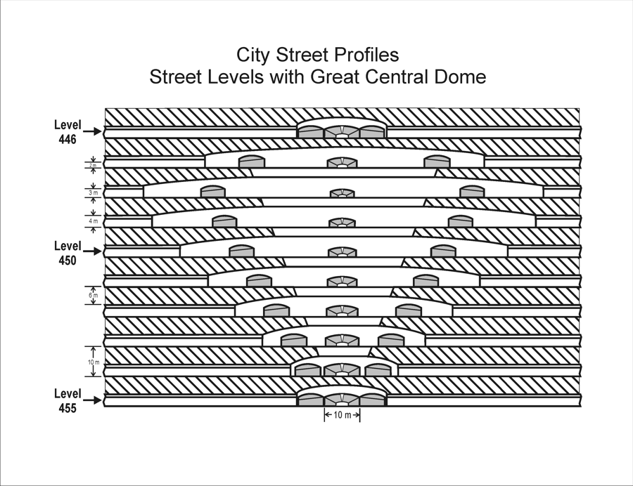
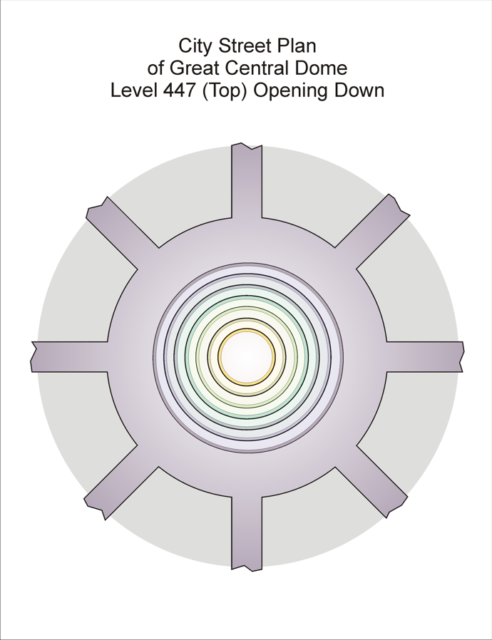
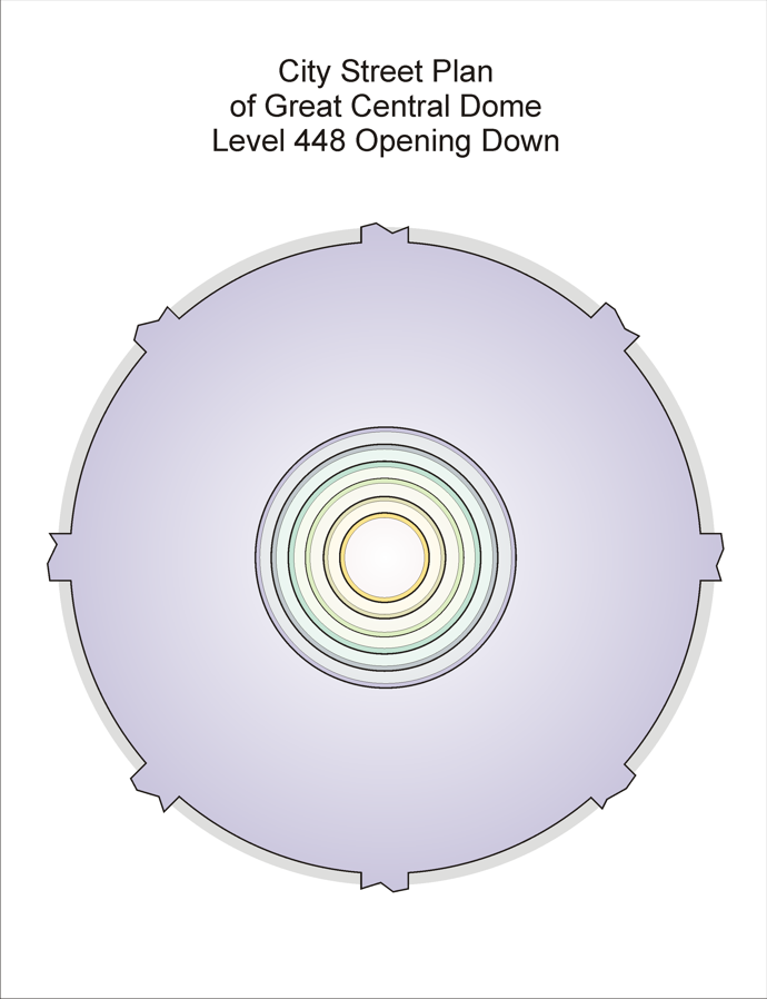
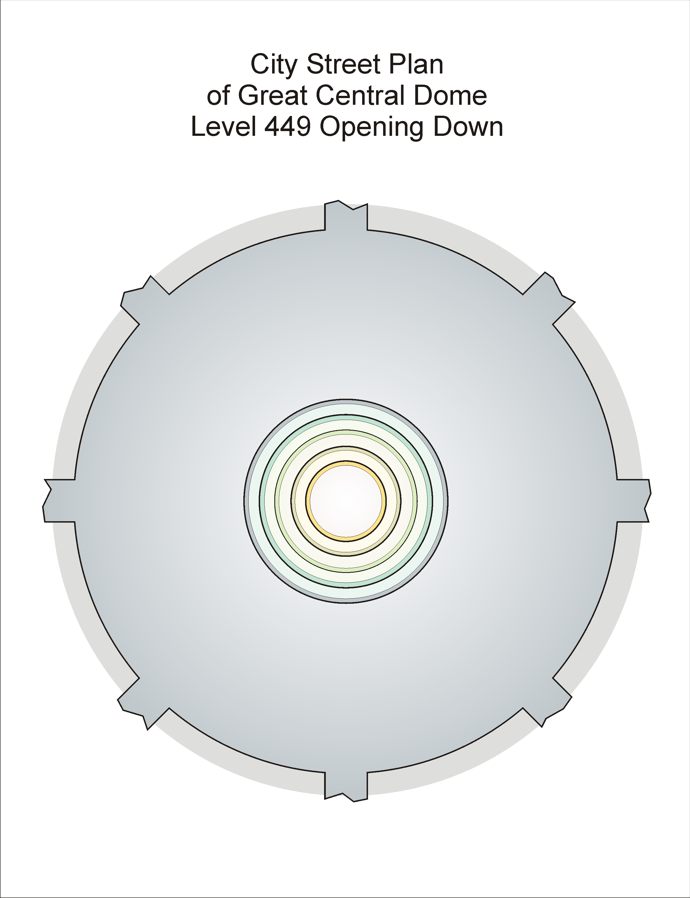
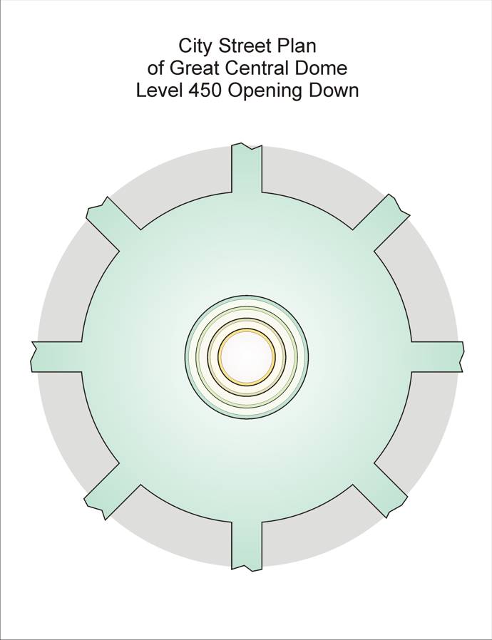
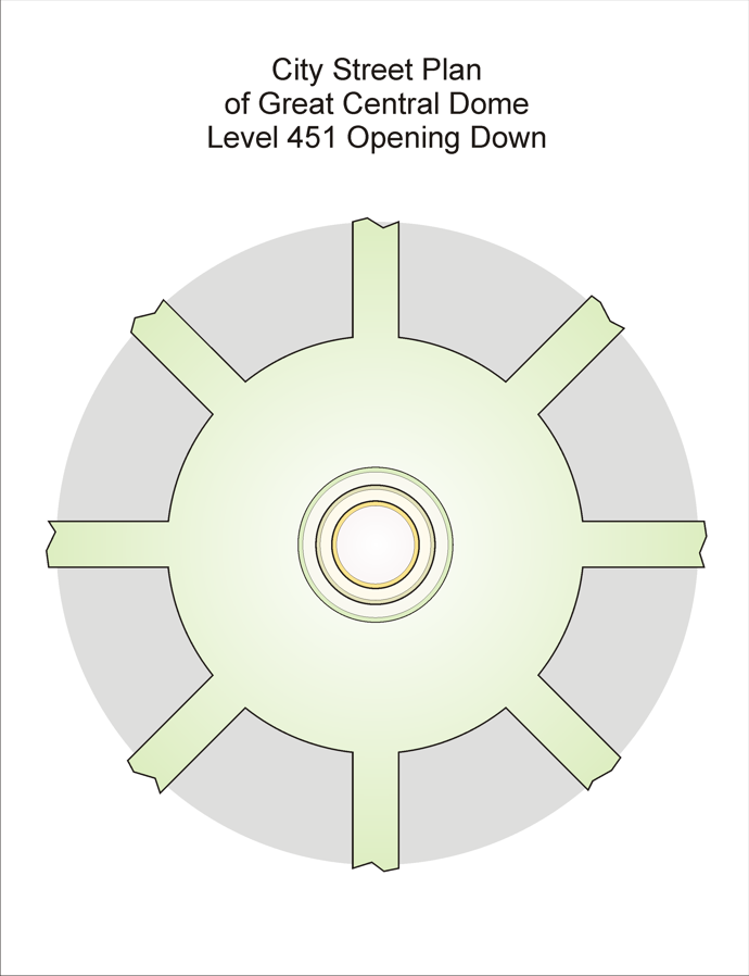
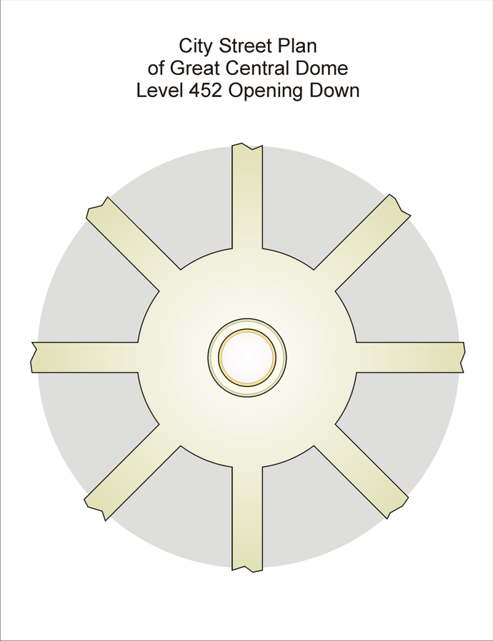
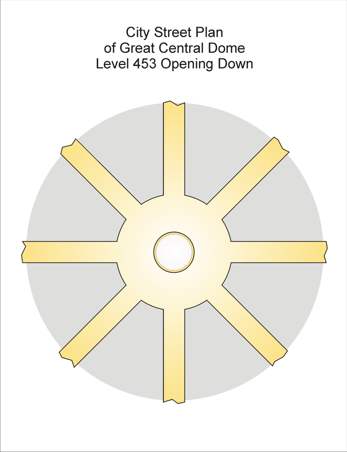
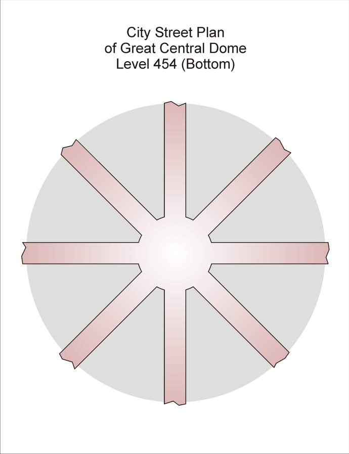
The largest dome structure is the Great Central Dome, at the City axis on Level 450, which extends from Level 447 at its top to Level 454 at the bottom. See City Streets and Great Central Dome. The circular center of each dome is cut away between each pair of adjacent levels to make visible all the levels included in the dome, from Level 447, called Great Dome Top, down to Level 454, termed Great Dome Floor. The largest opening is at Level 447, with the diameter of the openings decreasing down to Level 453. The broadest dome diameter, however, is at Level 448 (see Great Dome Two for an image).
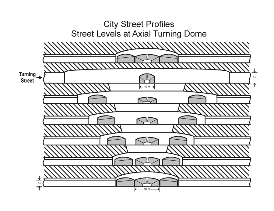
The next largest dome structure is the turning dome form, appearing at the axial starting points of each turning. The turnings themselves enter the dome from the four directions at the dome’s broad top level, and as with the Great Central Dome the dome center floors are cut away to make other levels visible. In this case the four levels below the level of the turning are open to the viewer. The City Streets and Axial Turning Dome image is a good example.
Other forms appear wherever turnings pass through levels near a radial, a ringway, or an intersection. The turnings are engineered so as to lie just outside, radially speaking, the ringways when they traverse the ringway levels. This adjustment insures that turning will not intersect a ringway from its floor or ceiling – an awkward situation that would require some complex structures to accommodate.
CITY LOCATION ADDRESSES
The sheer number of levels and rings, and the complexity added by the turnings and the proliferating radials, make name-based addressing useful at the most-local and most-familiar ranges for City residents. The Colonists, impressed by the symmetrical geometry of the City‘s layout, devised a rather-cumbersome location addressing system which has survived since their arrival over ten thousand years before Descending Road‘s action begins. It constitutes the official method for locating a home or a business or a meeting-place, even though localized names and memorial names are in plenty in all parts.
Levels: The system numbers levels from the surface (Level 0) down through the City‘s ellipsoid. Thus the top level is 0 at the surface, and the bottom level is 780 in Babiar, 7800 meters below the surface. The level at the exact City center is 450. In a few regions of the City, interlevels exist halfway between two adjacent normal levels, and in that case a ‘half’ designator marks them as such.
Rings: The system numbers rings from the City axis outward, from zero at the axis to 350 at the equatorial periphery. In the complete form, the ring component of a location address has appended to it a code indicating how many radials fan outward from that ring. In normal usage, the code is omitted, since residents readily learn the rules by which the number of outward radials increases as one moves away from the City axis.
Radials: The system designates radials using an octant-plus-binary scheme, as follows. First, since there are eight radials originating at the City axis at each level, the octants are numbered counterclockwise from the northward radial (zero) around to the northeast radial (7). New radials are added at Rings 2, 4, 8, 16, 32, 64, 128, and 256, doubling the number of radials at each of these rings. The new radials at Ring 2 are identified by pairing the two radials between which they fall, e.g., the north-northeast radial would be called 0|7, while the east-northeast radial would be called 6|7 (the order of the two octant numbers does not matter). At Ring 4, the new radial between Radial 0 and Radial 0|7 is then called 0|0||0|7, in which Radial 0 is given a full designation of 0|0 to distinguish the elements of the final designation properly. The double stroke is used to separate visually the two identifiers of the adjacent radials.
By the time one is writing a complete address for a radial that has its beginning at Ring 256, the writing becomes tedious. For example, the radial adjacent on the west to the base northward radial at Ring 300 would be written in the full form as:
0|0|0|0|0|0|0|0|0||0|0|0|0|0|0|0|0|1|
This usage has largely been abandoned in favor of a simpler approach that has several variations, all of them shorter than the official form. The first variation omits the second identifier and all the separators except the double stroke, replacing the second identifier with a '+’ sign:
000000000||+
and this encouraged a paired use of the ‘’ sign to indicate clockwise movement to the adjacent radial in the opposite direction:
000000000||
which would be written in the long form as:
0|0|0|0|0|0|0|0|0||0|0|0|0|0|0|0|0|7|
The above simplification suits some people, but most resort to a second approach for nearly all the addresses they use frequently, especially those involving the longer designations. This variation compresses the designation even further by selecting an octant number and appending a '+’ or ‘’ followed by a multiplier which represents the number of radials counting in the + or – direction from the given octant number. The double stroke is omitted altogether. The address usages in the preceding short form would in the second variation be written as 0+ or 0, the number being omitted if it is equal to one. This is much shorter than either the official or the halved form, but it requires knowing the number of radials for any given ring. This number is not difficult to keep in mind, since it is always a power of two, and increases at each ring with a number equal to a power of two.
Turnings: Turnings present considerable difficulty in addressing. A turning changes both in level and in distance from the City axis and equator. Turnings intersect radials and ringways, and sometimes all three intersect at a single crossing, called an ‘Aswal’. The formal mode of addressing a location on a turning uses the top level of the turning, the octant of the turning at its top, and a number indicating the distance along the turning from that top anchor point. For the topmost turnings, these numbers can be very large for addresses near the lower end of such a turning.
Most City dwellers ignore such designations. Each turning has an informal name gradually established and used over millennia, and those names are used along with the nearest level above the location on the turning and a count of doors down the turning from that level.
Specific Locations: The door count is used once the nearest ringway and radial inward and clockwise respectively from the location are given. Thus if a location is on a radial, the radial is given, the ringway is given, and then the door count from that intersection along the appropriate direction is given.
CITY ADDRESSING EXAMPLES
In the official form, the components of a City address are given with prefixes identifying each one. Each prefix is a single symbol rendered to contrast with the address component it identifies. Here the following symbols will be used to illustrate a standard City street address:
L for level
R for ring
D for radial
O for doors outward along radial
T for doors counterclockwise from radial
The address:
L408 R27 D0|0|0|0|0|0|0|0|0||0|0|0|0|0|0|0|0|1| O2
means Level 408, Ring 27, Radial the next one counterclockwise from the northward radial, the second door outward along that radial. The radial usage is the same as the example shown earlier. Here the abbreviated second form of the radial usage would be favored:
L408 R27 D0+ O2
but this is not the final word in regular usage. Quick usage assumes the order of components given, and simply inserts a slash separator between them:
408/27/0+/2
risking misreading when haste happens, but making the writing simpler. Now, locals in the area have other ways of naming this address that are based on everything from landmarks to coordinates based on nearby intersections. The given address above would most likely be given by a dweller in that area (Chunk Zone) as:
A-Meridenn/+/O2
meaning two doors up the radial west of the northward one issuing from Aswal Meridenn.
City Layout
The City‘s sheer size makes visualization very hard. Here is a profile of half of the City, cut through its central vertical axis, showing 10-level lines to illustrate the scope of the whole setting.
CITY SIDE PROFILE
 |
Looking down at the very top of the City, laid open to see the layout of radial and ringway streets, we can appreciate the architecture and some of the scale involved. These images only show the top three levels of radial and ringway streets. Note that as the streets fan outward from the City axis, the number of radials doubles whenever the length of a ringway block exceeds a certain value.
CITY TOP LEVELS
| Level | City Top Level Street Plans |
| Streets of Level 1 | 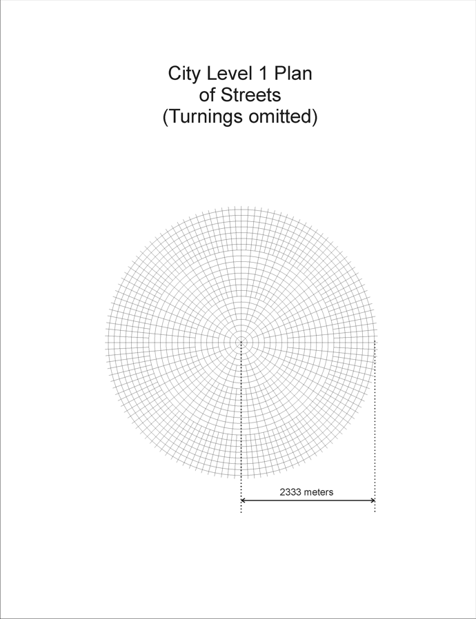 |
| Streets of Level 2 | 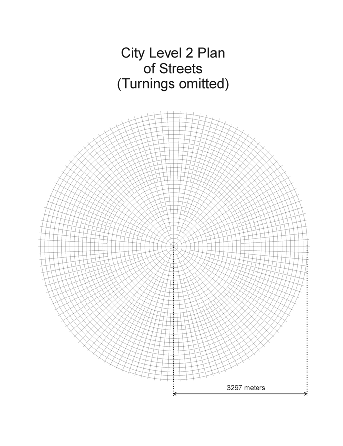 |
| Streets of Level 3 | 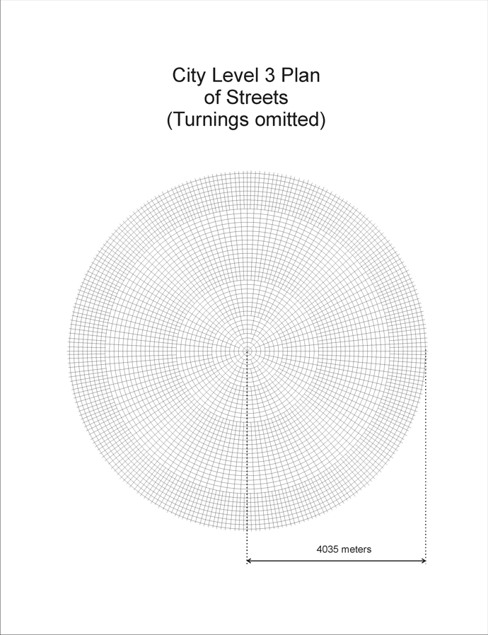 |
| Some details of Level 1 | 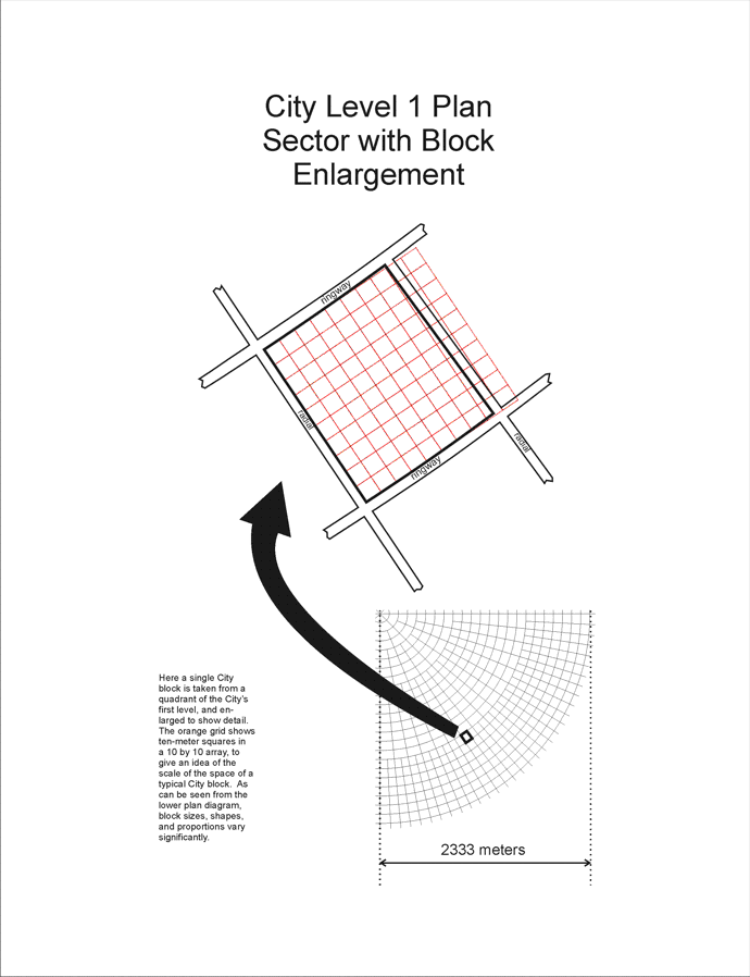 |
Looking down at the top of the City from a greater distance, laid open to see the diameters of the City‘s fifty top levels, we see the sheer size of just this small part of the metropolis. For comparison with the scale of the top three levels, one image here shows the entire top level with its street pattern.
CITY TOP 50 LEVELS
| Image Description | City Top Level Diameters |
| Diameters of the top 50 levels | 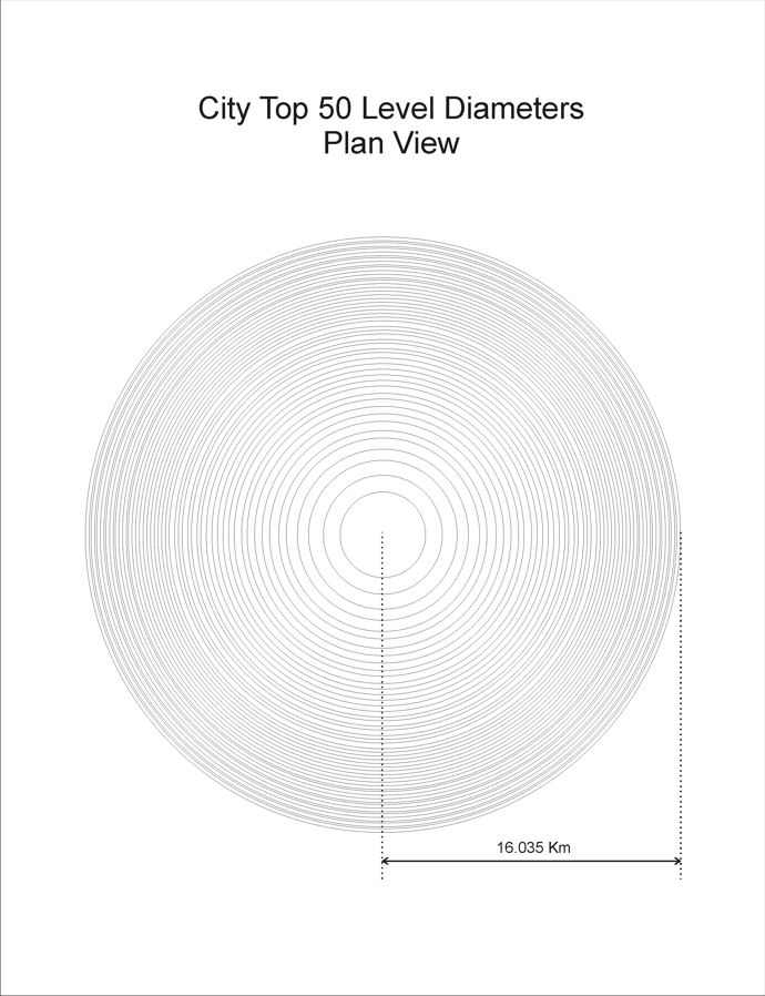 |
| Diameters of the top 50 levels with all of Level 1 detail showing | 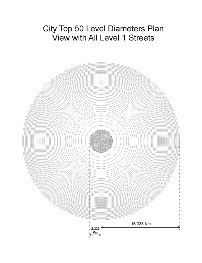 |
| Oblique view of the top 50 levels | 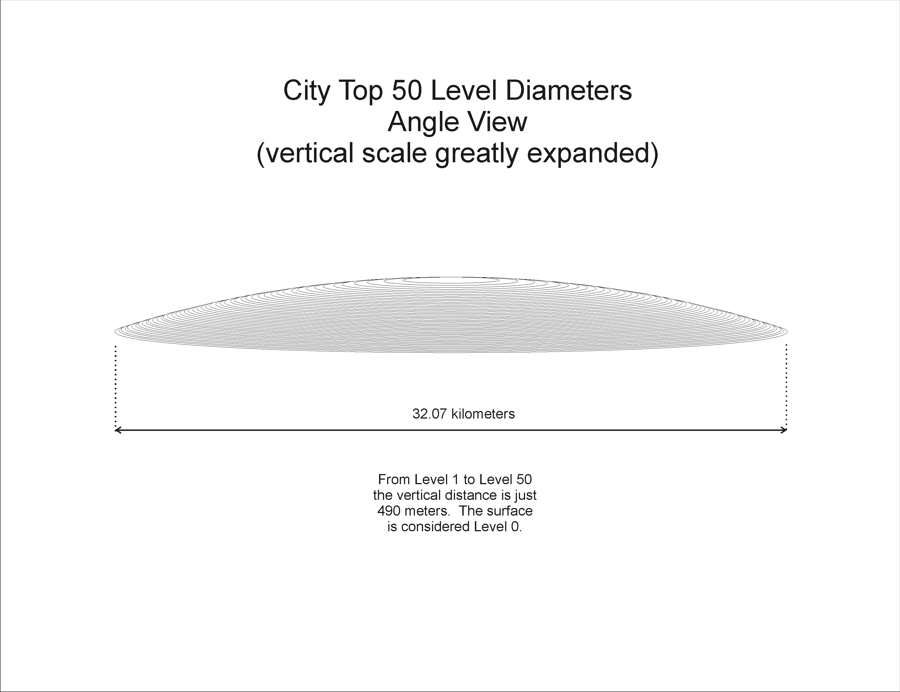 |
City Closeups
We move in closer to see an example of a City crossing of radial and ringway, where a dome is carved out, and shops and other establishments do business.
CITY LOCAL STREET PLAN
 |
City neighborhoods follow similar plans, with spacious homes and easy access.
CITY HOME PLAN
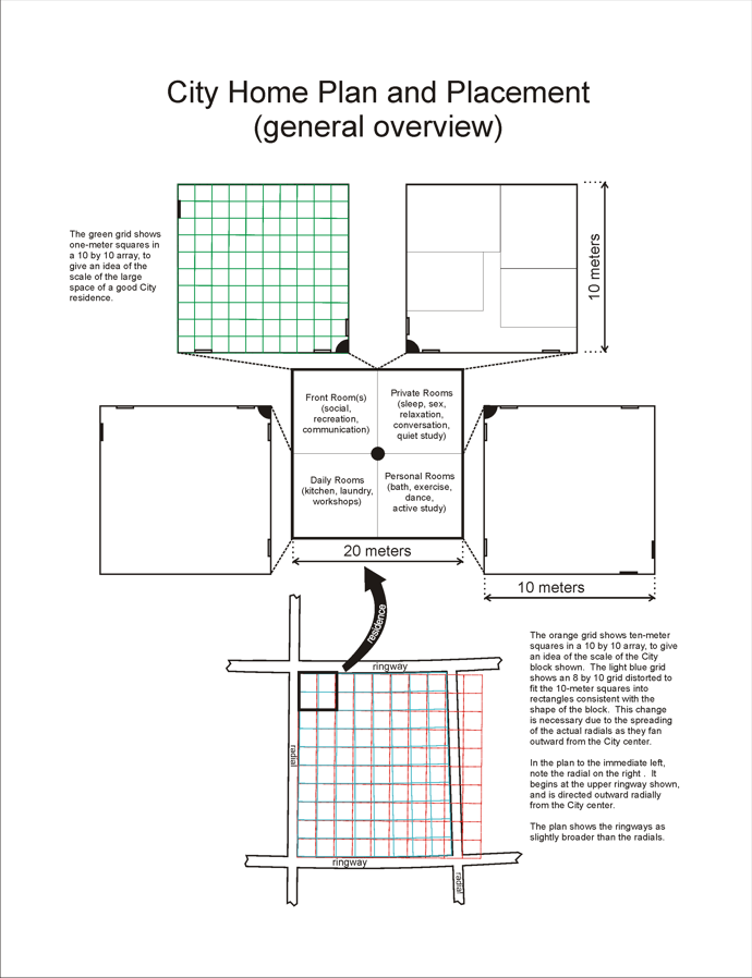 |
City Streets
Streets and domes define City social life.
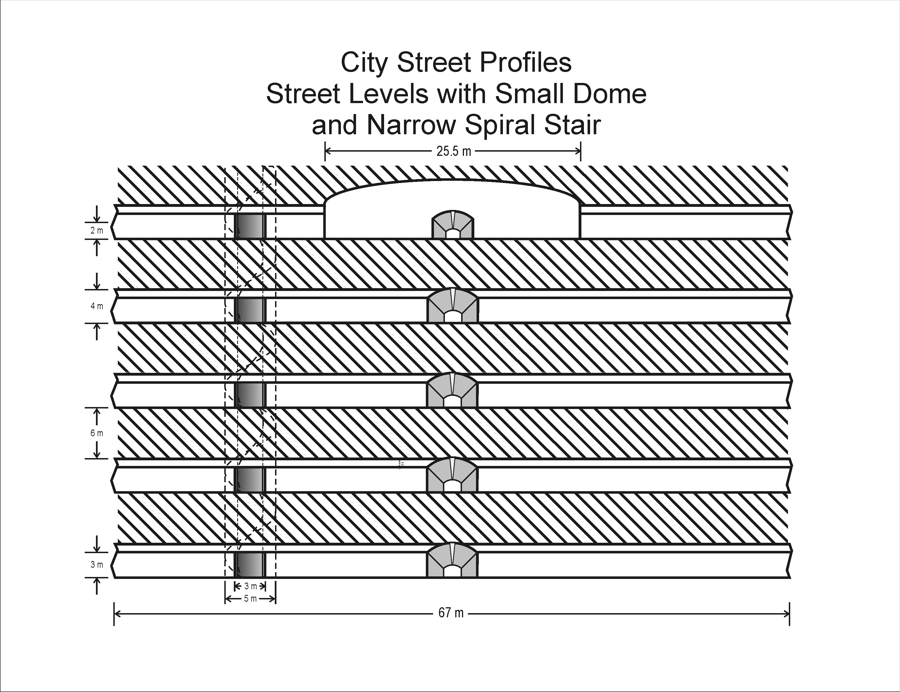
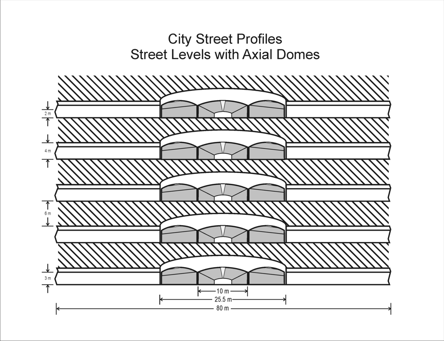
CITY STREET PROFILES
| Dome and Stair | Axial Domes | Axial Turning Domes | Great Central Dome |
 |
 |
 |
 |
The Great Central Dome is a beautiful, multilayered, open structure at the very center of the metropolis. Here are its layers, one by one, looking straight down through the opening they share.
THE GREAT CENTRAL DOME
| Central Dome Top Views | Central Dome Top Views | Central Dome Top Views | Central Dome Top Views |
 |
 |
 |
 |
 |
 |
 |
 |
Turnings must be visualized from a distant perspective to appreciate their beauty and intricate structure.
CITY TURNING DIAGRAMS
| City Turning Roads | Notes |
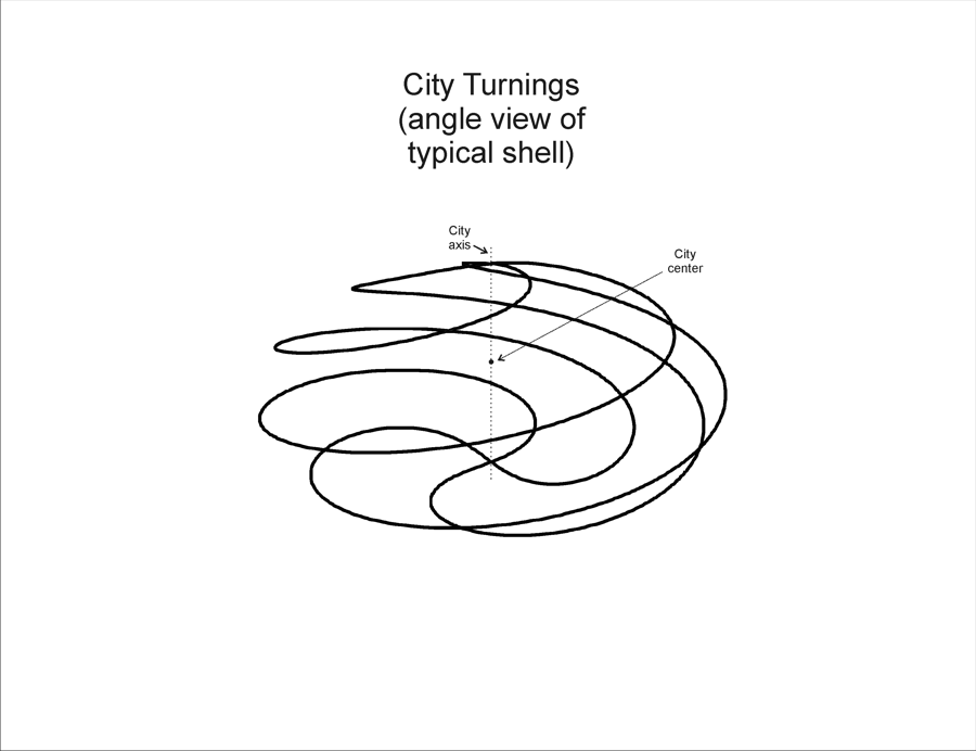 |
A side perspective view of one of the four sets of four turning roads each, spiraling around an ellipsoidal contour of the City. |
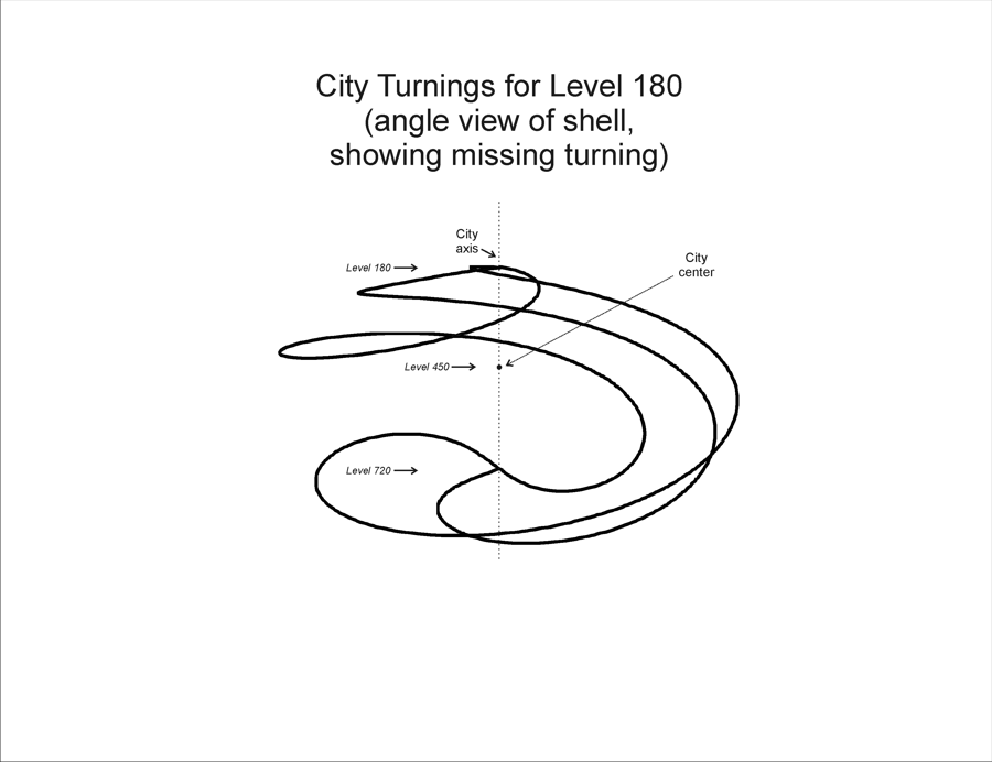 |
A side perspective view of the one seemingly-incomplete set of three turning roads, originating at Level 180. |
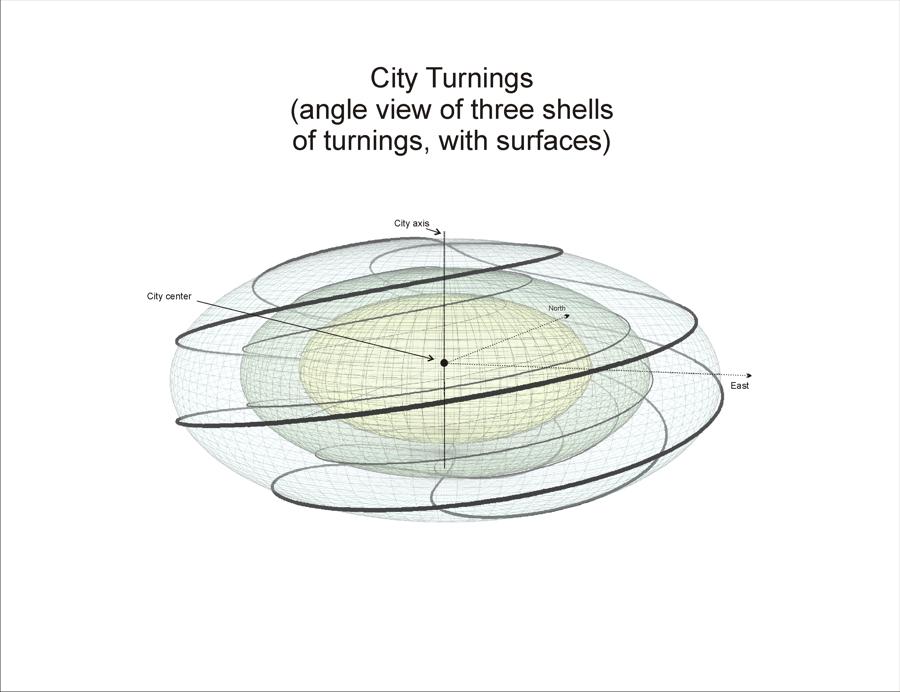 |
A side perspective view of three of the four concentric sets of turning roads. |
Gran Dar, called the City simply because of its unique size and character, is the hub of all governance, knowledge, and organization on Tarnus. Its structure and appearance still carry mysteries predating the Colonization. Here are a few diagrams of its layout and physical features.
CITY AIRSHAFT DIAGRAM
 2x3.png) |
CITY AIRSHAFT PLAN DIAGRAM
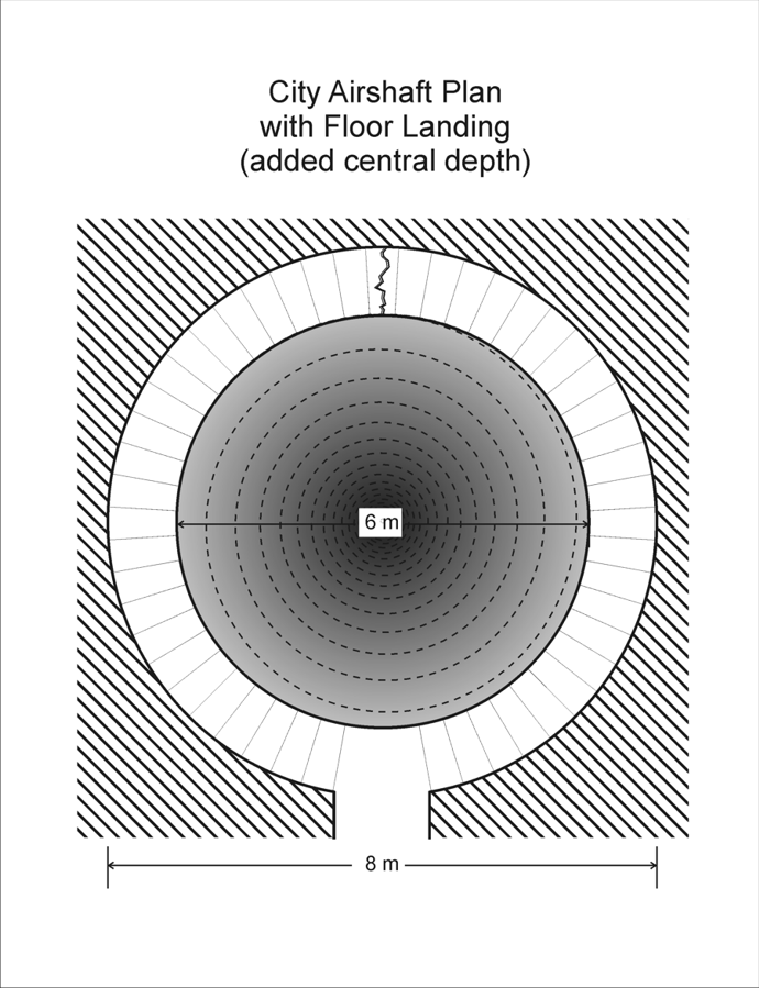 |
Stairs
CITY STAIR DIAGRAM
 2x3.png) |
This article will be updated and extended as needed.